 Runbo provides a series of low-power, small-scale GNSS modules, covering standard positioning, high-precision (RTK), inertial navigation positioning and other scenarios, which can meet various industry requirements. The standard positioning module is only for common precision needs, which is generally single frequency band, without RTK algorithm prebuilt; While high-precision and inertial navigation positioning can be used to have higher requirements for positioning accuracy and scene. High-precision positioning requires the collarboration of differential reference stations, which can generally reach sub-meter or even centimeter accuracy. The positioning principle is that the terminal receives the navigation satellite as a receiver to obtain the basic positioning, and sends the positioning data to the differential reference station. The differential reference station returns the corrected original positioning data according to this positioning data. After receiving the corrected data, the terminal will calculate the corrected positioning coordinates through differential decomposition. According to the positioning accuracy, it can be listed with "single point solution", "differential solution", "floating point solution" and "fixed solution", and the positioning accuracy is gradually improved.
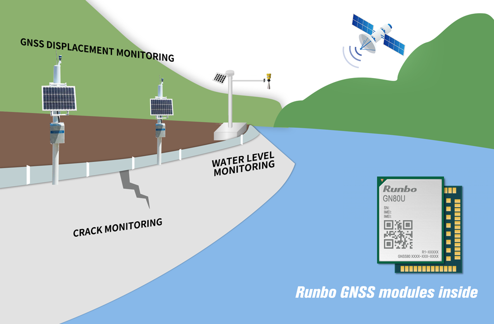
Taking the railway construction scene as an example, railway construction often faces complex and changeable terrain and geology, and the traditional surveying methods are difficult to meet the construction requirements in terms of efficiency and accuracy. The support of GNSS surveying and mapping technology has greatly shortened the time required for surveying and mapping in railway construction, effectively improved the working efficiency, and improved the quality of railway engineering surveying. Another scenario in railway is maintenance. The maintenance personnel with high-precision terminal need to be able to accurately locate on which rail to avoid affecting the operation of trains on the near rail or unnecessary safety hazards. When the personnel close to the running train rail, they will give a real-time warning of danger. Once the personnel walk on the rail for maintenance, the position can be displayed on the high-precision map in real time for the convenience of the back-end personnel to view.
| UART | Support |
| IIC (NMEA) | / |
| CAN | Support |
| Resetting | Support |
| Time pulse | Support |
 Be responsible for system guidance and BSP related commissioning. He is good at the development of peripheral Android (Linux) drivers related to modules, is familiar with various hardware bus interfaces, has many years of development experience in the middle layer or framework layer of Android, and can guide and cooperate with App engineers to complete better development.


